


Learn More: Your Disaster Response & Preparation Guide
Free Online Disaster Planning Resources for Fleets
When fleet managers are planning to mitigate the risks associated with natural disasters, they have online tools at their disposal. Most are provided by government agencies. Here are details about several valuable resources that are free.
May 29, 2025
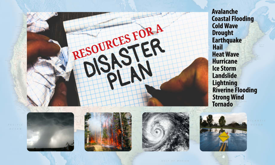
There are 18 recognized natural hazards in the U.S. and fleet managers can use online tools to assess the risk for specific locations well ahead of any natural disaster. Many are provided by government agencies, free.
Photo: Work Truck
5 min to read
While fleet managers have an abundance of information at their fingertips from fleet management companies, fuel management companies, and telematics providers, there are still some additional resources available to help them prepare for natural disasters.
Want to know what the greatest natural disaster risks are for your location, or any of your locations?
Want to track inbound weather that might threaten a jobsite or one of your facilities?
What if you want to help your employees and drivers be better prepared for a natural disaster?
Those answers are easy to find online and, for the most part, are provided by the federal government.
The Federal Emergency Management Agency (FEMA) recognizes 18 natural hazards. For each of those hazards, FEMA provides extensive data that any fleet manager can sort to create a detailed report of the risk profile for one or even multiple locations
The 18 natural hazards, as outlined by FEMA, are:
Avalanche
Coastal Flooding
Cold Wave
Drought
Earthquake
Hail
Heat Wave
Landslide
Lightning
Riverine Flooding
Strong Wind
Tornado
Tsunami
Volcanic Activity
Winter Weather
FEMA National Risk Index
The Federal Emergency Management Agency (FEMA) provides the National Risk Index Map as a tool for individuals, businesses, governments, and communities to evaluate risk from 18 natural disasters.
It leverages available source data for natural hazards and community risk factors to develop a baseline risk measurement for each United States county and Census tract.
How to use it:
Click Explore the Map
Enter your location of interest by city, county, or address
This generates a Risk Index Overview for that location
Use this to review which natural disasters are most likely and see Hazard Type Risk Ratings for each of the 18 natural disaster types.
Create Report – A button located at the lower right allows you to create a report, which can be shared or printed for use in disaster planning.
Compare to Other Counties – This will generate a report that compares multiple locations. For example, if you have fleet offices in multiple locations, this allows you to gain a single-pane view of risk factors across your entire operation.
This is a powerful tool that assembles the data you need to determine which natural disasters can potentially impact your fleet and provides insights into the level of risk associated with each.
You can explore the National Risk Index Map on FEMA’s website.
National Weather Service Radar
The National Weather Service is a valuable resource for evaluating current and impending weather risks. A great starting point is to visit the NWS Radar webpage directly.
The main landing page provides an overview of the U.S. map. However, when you enter a location in the search window, the map displays warnings by county. Alerts are provided in a drop-down menu for the selected area.
A good approach is to watch the weather that is heading into your area before it arrives.
Suppose you are under a tornado watch in your location, meaning conditions exist for a possible tornado to develop. But, to the west of you, a neighboring county is under a tornado warning, typically meaning rotation has been detected on radar.
On the NWS Radar page, you can see the details of the warnings for that community and watch the storm’s track to know when it is heading your way. While many apps and smartphone features will sound an alert when your area is issued a warning, using this map allows you to see warnings in other adjacent areas and explore the details, providing an advanced look at potential threats that may reach your location.
National Hurricane Center
The National Hurricane Center and Central Pacific Hurricane Center, part of the National Oceanic and Atmospheric Administration, are a resource when understanding the risk and threat of hazardous tropical weather.
The purpose of each, according to the federal website, is:
“The NHC mission is to save lives, mitigate property loss, and improve economic efficiency by issuing the best watches, warnings, forecasts, and analyses of hazardous tropical weather and by increasing understanding of these hazards.”
“The CPHC issues tropical cyclone warnings, watches, advisories, discussions, and statements for tropical cyclones between 140 degrees west longitude to the International Dateline.”
The centers provide estimates of the number of named storms each year with analysis.
When storm season kicks into gear, the National Hurricane Center’s website provides a Seven-Day Graphical Tropical Weather Outlook with a map and details. The maps, which include Atlanta, the Eastern Pacific, and the Central Pacific, also provide a two-day outlook.
The NHC also provides a series of preparedness articles, which can be found on the center’s website.
Preparing Disaster Kits for Home, Office & Drivers
There are several online options available for those seeking guidance on assembling disaster kits and supplies. While most offer tips and lists for disaster kits for homes and families, fleets may want to assemble appropriate kits for drivers who may be stranded in unique situations, like extreme heat, extreme cold, or winter weather.
Ready.gov: Tips from Homeland Security
The U.S. Department of Homeland Security provides a website, Ready.gov, as a resource for disaster education and preparedness. Included among the resources is a downloadable set of Hazard Information Sheets.
The site also provides downloads such as “Know Your Alerts and Warnings,” “Are You Ready? Guide,” and “Document and Insure Your Property.”
Also, a checklist of essential items is available to help individuals prepare a disaster kit that can sustain them for several days. Suggested items include food, water, a first aid kit, a local map, cell phone chargers, and more.
Other online sources for disaster kit planning include:
Get Prepared, Government of Canada website
British Columbia’s emergency management website
U.S. states' emergency management agencies’ websites
Develop Crisis Communications Plans
Another aspect of preparing for natural disasters is developing crisis communications plans.
According to Ready.gov, “The crisis communications plan is an important component of a business’ preparedness program. A business must be able to respond promptly, accurately, and confidently during an emergency in the hours and days that follow.”
In advance, you should plan methods of communicating with:
Employees
Customers
Suppliers
Management
Government officials and regulators
Contact information for each category should be compiled in advance and accessible during and after a disaster. Ready.gov provides additional information on communication planning.
Subscribe to Our Newsletter
More Operations

Sponsored•August 1, 2026
Top 50 Executive Fleets
It is that time of year again! Time for the 2026 list of the Top 50 Executive Fleets, presented by Automotive Fleet and Volvo as part of its annual Fleet 500. Download now to see this year's list of companies!
Read More →
Behind the Scenes: Building the Ringmaster of the Road from Body to Paint Part 2
The body is built, the paint is on, and Team Fletcher’s Soap Box Derby car is nearly ready for testing ahead of race day in Akron.
Read More →
It's All Downhill from Here! Fleet Industry Raises $22,000 for Skilled Trades Scholarships
Work Truck’s Lauren Fletcher and Automotive Fleet’s Chris Brown turned a friendly racing rivalry into $22,000 for automotive technology and skilled trades scholarships.
Read More →
Fleet Confidence, Safety, and Smarter Risk Management Lead This Month
This month’s TruckChat: Top Monthly News Recap explores what it takes to build confidence across a fleet, from stronger leadership and technician support to better safety preparation, smarter use of telematics, and clearer plans for when something goes wrong.
Read More →
From Fleet Operator to OEM Leader: Tina Kourakos’ Career Lessons
Tina Kourakos shares the lessons, relationships, and career pivots that shaped more than 30 years in fleet, plus the advice every new fleet manager should hear.
Read More →
WEX Brings Standard Fleet's Connected Vehicle Platform to Fleet Customers
This week’s product launch with Standard Fleet’s connected vehicle platform reflects WEX Venture Capital's strategy of turning startup innovation into customer solutions. Standard Fleet is now available to WEX fleet customers.
Read More →
Meet Atlas: Motive's AI Assistant for Fleets
Artificial intelligence is becoming a practical tool for fleet operations. In this video, Emily Parsons introduces Atlas, Motive's AI-powered assistant that combines conversational search with the ability to perform actions across the Motive platform.
Read More →
Sponsored•July 23, 2026
The Top 300 Commercial Fleets
The Top 300 Commercial Fleets: See the List
Read More →
NTEA Releases Updated Federal Excise Tax Guide for the Work Truck Industry
NTEA’s latest revised edition of its Federal Excise Tax Guide for the Work Truck Industry is now available to help fleet leaders navigate complex federal tax requirements.
Read More →
Super Dispatch Powers Centralized Vehicle Transport Operations for Merchants Fleet
Merchants Fleet has replaced fragmented transportation processes with Super Dispatch’s unified, API-powered platform to improve visibility, automation, and carrier performance.
Read More →