

Geotab ITS Study Shows Impact of U.S. Bridge Closures on Freight and Supply Chains
Geotab reveals how bridge closures disrupt traffic, increase risks, and impact work truck fleets. Discover the full report and insights.
October 17, 2024

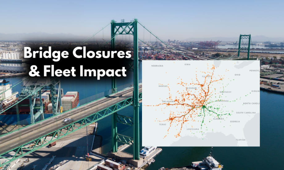
Geotab's analysis of U.S. bridges (including the Vincent Thomas Bridge), highlights the significant impact of closures on traffic, driver safety, and supply chains critical to work truck fleets.
Photo: Work Truck | Geotab ITS
4 min to read
Geotab ITS has released an in-depth analysis of commercial freight data from five critical U.S. bridges, revealing the far-reaching effects of bridge closures on traffic congestion, harsh driving events, and supply chain disruptions.
The findings offer a stark reminder of the importance of resilient infrastructure for the nation's economy, particularly for work truck fleets that rely on these critical routes for efficient goods movement.
The Data: How Bridge Closures Impact Traffic and Freight
The report highlights five major U.S. bridges:
Memphis-Arkansas Bridge and Hernando de Soto Bridge (Tennessee-Arkansas)
Vincent Thomas Bridge (Los Angeles, CA)
George Washington Bridge (New Jersey-New York)
Ambassador Bridge (Detroit, MI-Windsor, Ontario)
Francis Scott Key Bridge (Baltimore, MD)
The study found that any bridge closure, regardless of duration, can significantly affect surrounding traffic, increase the risk of collisions, and disrupt the movement of goods.
For example, the two-week closure of the Memphis-Arkansas Bridge in June 2024 led to a staggering 1,750% increase in harsh driving events on the Hernando de Soto Bridge. Traffic volume also increased by 23%, and travel times into Tennessee rose by 70.8% during peak hours.
Geotab ITS's analysis underscores that these disruptions are not limited to the immediate region. Heavier congestion on the Hernando de Soto Bridge had knock-on effects on freight movement into states such as Texas, Ohio, Georgia, and Indiana, showcasing how critical these bridges are to broader U.S. supply chains.
Why It Matters: Bridge Closures and Work Truck Fleets
The insights from Geotab's analysis are significant for work truck fleets. Fleets operating light- and medium-duty trucks rely heavily on efficient routes to meet delivery schedules and minimize operational costs.
A single bridge closure can have a cascading effect on a fleet's ability to maintain timely deliveries, avoid detours, and keep drivers safe. Increased congestion and harsh driving conditions can also lead to higher vehicle wear and tear, including premature brake wear, increased fuel consumption, and a greater risk of accidents.
The report emphasizes that understanding these data points can help fleet managers make more informed decisions when planning routes and assessing risk during infrastructure disruptions.
By leveraging commercial vehicle traffic data, fleets can adjust real-time routes to avoid problem areas, minimize downtime, and ensure that goods continue to move efficiently, even when key bridges are out of service.
Key Bridges in Focus: How Closures Affect the Nation
Geotab's analysis of the five key bridges offers a detailed look at the specific impacts fleets and drivers may face during closures:
Memphis-Arkansas & Hernando de Soto Bridges (Tennessee-Arkansas): The Memphis-Arkansas Bridge, which connects Tennessee and Arkansas, saw a 1,750% increase in harsh driving events during a two-week closure. The resulting traffic spillover on the Hernando de Soto Bridge increased travel times by 70.8% and disrupted commercial vehicle movement into multiple states.
Vincent Thomas Bridge (Los Angeles): As a major thoroughfare for freight moving to and from the Port of Los Angeles, construction on the Vincent Thomas Bridge will likely cause significant delays for fleets. Heavy-duty trucks make up 28% of the vehicle traffic here, meaning supply chain delays will likely ripple across the region and beyond.
George Washington Bridge (New Jersey-New York): Known as the busiest bridge in the world, the George Washington Bridge handles 59% of all trips between New Jersey and New York. Geotab's data reveals a sharp increase in collision risks during severe weather, highlighting the need for better planning to mitigate traffic hazards.
Ambassador Bridge (Detroit-Windsor): A critical connection between the U.S. and Canada, the Ambassador Bridge saw significant delays during a six-day closure in 2022, with disruptions reaching as far as Nashville and Cincinnati. The bridge is a vital route for long-haul freight, and any closure can have an outsized impact on regional economies.
Francis Scott Key Bridge (Baltimore, Maryland): Following its collapse in March 2024, rerouting commercial vehicles through alternate tunnels resulted in up to a 24% increase in drive times, with 53% of traffic diverting to the Fort McHenry Tunnel. The long-term effects of this closure demonstrate the challenges of quickly adapting to major infrastructure failures.
Using Data to Plan for the Future
Geotab's report not only highlights the challenges posed by bridge closures but also emphasizes the role of data in planning for resilient infrastructure. By analyzing commercial vehicle traffic patterns, transportation planners, government agencies, and fleet managers can better prepare for infrastructure projects and minimize the impact on freight movement.
"Bridges are critical to communities, connecting cities, states, and regional hubs. Our commercial vehicle freight data demonstrates a bridge shutdown's far-reaching effects on road safety, driver behavior, and supply chains," said Nate Veeh, Associate Vice-President of Intelligent Transportation Systems at Geotab.
With federal investments of $5 billion allocated to bridge initiatives across the U.S., data-driven insights will be essential in helping regions enhance their preparedness for future closures and ensure that goods continue to move smoothly through the nation's critical transportation infrastructure.
For the full analysis and insights, visit Geotab's Bridge Freight Analysis Report.
More Operations

Sponsored•August 1, 2026
Top 50 Executive Fleets
It is that time of year again! Time for the 2026 list of the Top 50 Executive Fleets, presented by Automotive Fleet and Volvo as part of its annual Fleet 500. Download now to see this year's list of companies!
Read More →
Behind the Scenes: Building the Ringmaster of the Road from Body to Paint Part 2
The body is built, the paint is on, and Team Fletcher’s Soap Box Derby car is nearly ready for testing ahead of race day in Akron.
Read More →
It's All Downhill from Here! Fleet Industry Raises $22,000 for Skilled Trades Scholarships
Work Truck’s Lauren Fletcher and Automotive Fleet’s Chris Brown turned a friendly racing rivalry into $22,000 for automotive technology and skilled trades scholarships.
Read More →
Fleet Confidence, Safety, and Smarter Risk Management Lead This Month
This month’s TruckChat: Top Monthly News Recap explores what it takes to build confidence across a fleet, from stronger leadership and technician support to better safety preparation, smarter use of telematics, and clearer plans for when something goes wrong.
Read More →
From Fleet Operator to OEM Leader: Tina Kourakos’ Career Lessons
Tina Kourakos shares the lessons, relationships, and career pivots that shaped more than 30 years in fleet, plus the advice every new fleet manager should hear.
Read More →
WEX Brings Standard Fleet's Connected Vehicle Platform to Fleet Customers
This week’s product launch with Standard Fleet’s connected vehicle platform reflects WEX Venture Capital's strategy of turning startup innovation into customer solutions. Standard Fleet is now available to WEX fleet customers.
Read More →
Meet Atlas: Motive's AI Assistant for Fleets
Artificial intelligence is becoming a practical tool for fleet operations. In this video, Emily Parsons introduces Atlas, Motive's AI-powered assistant that combines conversational search with the ability to perform actions across the Motive platform.
Read More →
Sponsored•July 23, 2026
The Top 300 Commercial Fleets
The Top 300 Commercial Fleets: See the List
Read More →
NTEA Releases Updated Federal Excise Tax Guide for the Work Truck Industry
NTEA’s latest revised edition of its Federal Excise Tax Guide for the Work Truck Industry is now available to help fleet leaders navigate complex federal tax requirements.
Read More →
Super Dispatch Powers Centralized Vehicle Transport Operations for Merchants Fleet
Merchants Fleet has replaced fragmented transportation processes with Super Dispatch’s unified, API-powered platform to improve visibility, automation, and carrier performance.
Read More →